|
Gambar Alat
|
Spesifikasi
|
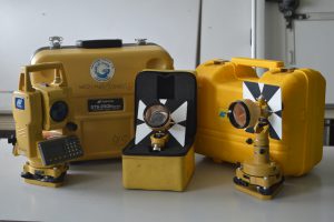 |
Total Station (GTS-230N Series)
Total Station ini dilengkapi dengan spesifikasi sebagai berikut:
• Pembacaan sudut : 1” / 5 ”
• Ketelitian Jarak : ± -( 3mm+ 2ppmxD)
• Pembesaran Lensa : 33x
• Ketelitian Sudut : 3”
• Internal Memory :Points
• Display : 2 Muka
• Jarak ukur 1 Prisma : 3.000 M
• Jarak ukur 3 Prisma : 4.000 M
|
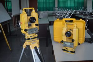 |
Theodolit Digital (ET 1005)
Digital Theodolite Horizon ET 1005
SPECIFICATION :
TelescopeImage : Erect
Magnification : 30x
Clear Objective Aperture : 45mm
Resolving Power : 3”
Field of View : 1°30’
Shortest Focusing Distance : 1.4m
Stadia Multiplication Constant : 100
Stadia Additive Constant : 0
Tube Length: 157mm
Measurement
Angle Measurement Reading System : Increment encoder
Diameter of Circle (V.Hz) : 79mm
Minimum Reading (selectable) : 1” or 5”
Accuracy : 5”
Measurement Method : Increment reading
Horizontal Angle Dual sides
Vertical Angle : Single sides
Display
LCD 2 sides Double Line, Line segment,Built-in recticle illumination (utk kondisi pencahayaan yang buruk).
Data CommunicationI/O RS-232C
Level
Plate Levels (x2 at right angles to each other)30” per 2mm
Vertical Tilt Compensation (ET1002) Liquid Type (Electronic)
Compensating Range ± 3
Setting Accuracy : 1”
Circular Level 8’ per 2mm
Optical plummet
Image : Erect
Magnification 3x
Focusing Range : 0.5m
Field of View : 5° |
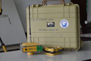 |
GPS Geodetic (Hiper Ga Series)*
Signal : GPS and GLONASS L1/L2 C/A,P-Code, Full Code & Carrier
Channels : 40 channels L1 / L2
Tracking : < 10 – < 60 seconds
Reacquisition : < 1 seconds
Accuracy :
• Static : Horizontal = 3mm + 0.5ppm x Distance ~ Vertical = 5mm + 0.5ppm x Distance
• RTK : Horizontal = 10mm + 1ppm x Distance ~ Vertical = 15mm + 1ppm x Distance
• DGPS : After Post Processing = 0.3m (0.98 foot) ~ Real Time = < 0.5m (1.64 foot)
Communication : Bluetooth® Wireless Technology
|
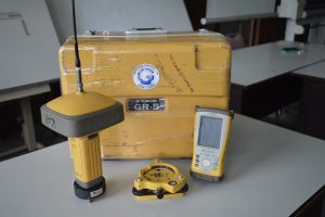 |
GPS Geodetic (GR-5 Series)*
Signal : Tracked G3 Technoogy (GPS, GLONASS, Gallileo)
Channels : 216 Universal channels
Tracking : WAAS / EGNOS / MSAS
Accuracy :
• Static : Horizontal = 3mm + 0.5ppm • Fast Static :Vertical = 5mm + 0.5ppm
• RTK : Horizontal = 10mm + 1ppm ~ Vertical = 15mm + 1ppm
Communication :
• Radio Type : Integrated UHF Transmit (TX) and Receive (RX), or 915MHz Spread Spectrum
• Base Radio Output : 0.01 – 1.0 Watt, user selectable
• Cellular Communication : Integrated GSM/GPRS or CDMA
• Wireless Comm : Integrated Bluetooth® 2.0 compliant |
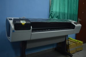 |
Plotter HP Designjet T1300
Laboratorium ini memiliki plotter dengan spesifikasi sebagai berikut:
- Max Print area : 44inch / A0+ (118cm)
- Max print speed : 28 sec/page on A1/D, 103 A1/D prints/hr (Line drawings)
- Print resolution : Up to 2400 x 1200 optimized dpi
- Technology : HP Thermal Inkjet
- Ink cartridge colors : Cyan (C), gray (G), magenta (M), matte black (mK), photo black (pK), yellow (Y)
- Printheads : 3 (G & pK, mK & Y, M & C)
- Line accuracy : +/- 0.1%
- Memory : 32 GB (virtual), 160 GB hard disk
- Print language : HP-GL/2, TIFF, JPEG, CALS G4, HP PCL 3 GUI Adobe, PostScript 3 (Optional), Adobe PDF 1.7
|
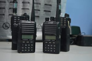 |
Handy Talky (BAOFENG UV-5R Series)
Laboratorium Kartografi memiliki 6 unit HT, 4 diantaranya adalah BAOFENG UV-5R Series dengan Spesifikasi :
- VHF/ UHF DUAL-BAND TWO WAY RADIO
- Frequency Range: 136-174 / 400-480MHz
- Dual-Band Display, Dual Freq. Display, Dual-Standby
- Output Power: 4 /1Watts
- 128 Channels
- 50 CTCSS and 104 CDCSS
- Built-in VOX Function
- 1750Hz Brust Tone
- FM Radio (65.0MHz-108.0MHz)
- LED Flashlight
- Large LCD Display
- High /Low RF Power Switchable
- 25KHz/12.5KHz Switchable
- Emergency Alert
- Low Battery Alert
- Battery Saver
- Time-out Timer
- Keypad Lock
- Monitor Channel
Channel Step: 2.5/5/6.25/10/12.5/25KHz |
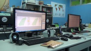 |
Personal Computer (PC)
Laboratorium ini memiliki 8 Unit PC dilengkapi dengan Spesifikasi sebagai berikut :
– Windows 7 64 bit
– Processors Intel(R) Core(TM) i5-3450 CPU @3.10 GHz (4 CPUs)
– Memory 4096MB RAM
– Grafik WinFast GT 520 (NVIDIA)
Dilengkapi dengan dukungan penuh Software Pemetaan, sebagai berikut:
– ArcGIS versi 10.3 dengan Lisensi Resmi (Esri Student License)
– ERDAS Imagine 8.4 (License)
– Quantum GIS
– OpenStreetMap.org
|
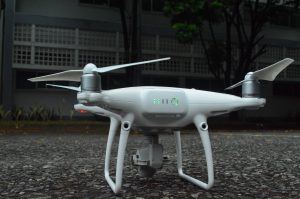 |
Drone Pemetaan
Laboratorium ini memiliki 1 unit Drone dengan seri DJI Phantom 4 Pro dengan spesifikasi sebagai berikut:
- Sensor CMOS 1 inchi resolusi 20MP
- Gimbal-Stabilized 4K60 / 20MP Imaging
- FlightAutonomy dengan Redundant Sensors
- 5 sensor untuk menghindari rintangan/halangan
- Top Speed 45 mph pada Sport Mode
- Jarak terbang maksimal 4.3 Miles (7Km)
- Visual Tracking of Moving Subject
- Waktu terbang hingga 20-30 Menit
|
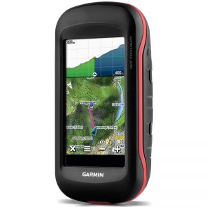 |
Receiver GPS : GARMIN Montana 650
- Layar sentuh 4” dengan tampilan TFT warna 65-K yang terang dan dapat dibaca dibawah sinar matahari.
- Anti air, anti debu dan kotoran.
- Memiliki kamera 5 MP dengan autofocus yang dapat disimpan secara otomatis dengan lokasi dimana gambar itu diambil. Melacak foto dan melihat lokasi di peta menggunakan basecamp ™ untuk penyimpanan gambar dengan menggunakan microSD ™.
- Mempunyai kompas elektronik 3 sumbu dengan kompensasi kemiringan, yang menampilkan arah meskipun anda tidak bergerak dan tanpa memiringkannya. Memiliki altimeter barometrik yang akan memantau perubahan tekanan untuk menentukan ketinggian yang akurat dan dapat membantu mengawasi perubahan kondisi cuaca.
- Menggunakan isi ulang baterai lithium-ion pack atau baterai AA.
- Dapat berbagi titik acuan, jalur, rute, dan geocache secara nirkabel dengan perangkat GPS Garmin lain yang kompatibel.
- Dapat digunakan di ATV sepeda, kapal, atau sebagai perangkat genggam di mobil. Kemampuan pemasangan otomatis dan peta City Navigator NT® untuk arah berkendara setiap belokan.
- Dengan kemampuan sensitivitas tinggi, unit penerima GPS yang mendukung WAAS, dan prediksi satelit HotFix® akan menentukan posisi secara cepat dan akurat.
- Mendukung file GPX geocaching untuk mentransfer geocache yang lebih menghemat kertas yang digunakan untuk menyimpan dan menampilkan informasi penting termasuk lokasi, dataran, kesulitan, petunjuk dan keterangan hanya dengan ukup unggah file GPX ke eTrex 10, lalu mulailah berburu cache.
|
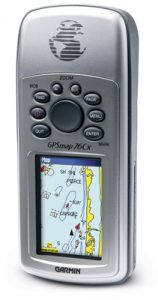 |
Receiver GPS : Garmin GPSmap 76CSx
- Teknolgi terbaru yang mempermudah menangkap signal satelit. WAAS-capable GPS receiver by SiRF
- Built-in quad-helix receiving antenna, bisa ditambah external antena
- Ukuran unit : 2.7” W x 6.2” H x 1.4” D
- Display: 1.5” W x 2.2” H, 2.6”-diagonal, 256-color, transflective TFT (160 x 240 pixels)
- Terdapat pilihan bahasa : English, Spanish, Portugese, and French languages.
- Berat 7.6 ounces with batteries (not included)
- Sensor pelengkap :
-Electronic compass displays accurate heading while standing still
-Barometric altimeter with automatic pressure trend recording
- LED backlit display and keypad
- Ketahanan batere : 18 jam (typical use) menggunakan 2 AA alkaline
- 1,000 waypoints dengan nama and graphic symbol; 50 reversible routes
- Position formats include Lat/Lon, UTM, Loran TDs, Maidenhead, MGRS, user grid, and more
- Audible alarms for anchor drag, arrival, off-course, proximity waypoint, and clock
- Large-numbers option for easy viewing; dual-position display mode
- Trip computer provides odometer, stopped time, moving average, overall average, total time, max speed, and more
- 10,000-point automatic track log; 20 saved tracks (500 points each) let you retrace your path in both directions
- Elevation computer provides current elevation, ascent/descent rate, minimum/ maximum elevation, total ascent and descent, average and maximum ascent and descent rate
- Navigation instructions can be shared with repeaters, plotters, and autopilots using NMEA protocols through the dedicated serial port
- Built-in celestial tables for sun and moon calculations and the best times to fish and hunt
- Compatible with most MapSource products. See the MapSource Compatibility table (top right) for a list of software that Garmin recommends with this product.
- Water resistant: IEC 60529 IPX7 standards
|